
Echo Lake Re-photographic Survey
by Elizabeth Black, July 2013
Elizabeth@ElizabethBlackArt.com
303-449-7532
The recent Forest Service fire mitigation plan for Echo Lakes has brought up several issues, including:
-
Has our our forest changed?
-
What role has fire played in the past at Echo?
A re-photographic survey can help answer these questions. Here are 14 pairs of THEN & NOW photographs of various places at Echo Lake, with notes about each one. My conclusions are at the end. If you have pairs of THEN & NOW photographs which you would like me to post on this web page, please email them to me at Elizabeth@ElizabethBlackArt.com.
I want to thank Tom and Lyn Schaefer and Little Echoes. Several historic photos here are from past Little Echoes, an invaluable resource.
If you want to zoom in on the photos, hit {Ctrl}+ and your screen will zoom in. To zoom out use {Ctrl}-.
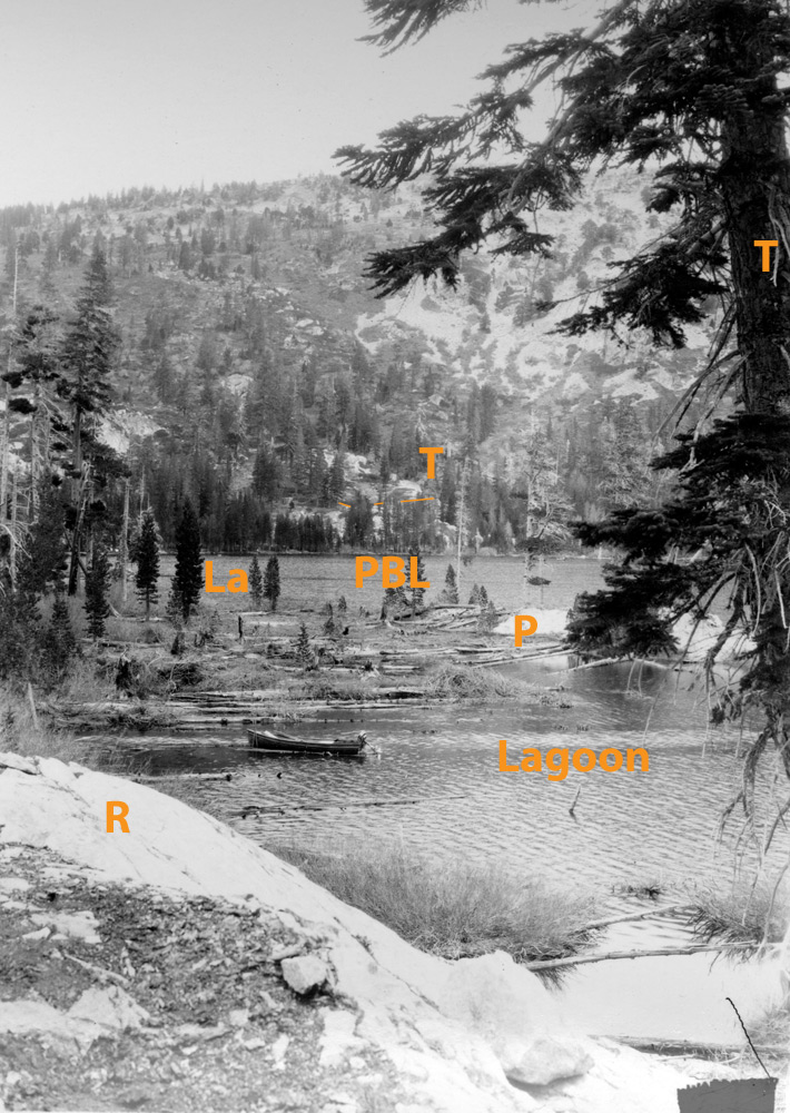
Photo pair #1: Lagoon, Point and Public Landing from Dyke Brown Deck, Hemlock Tract #13, 1928 and 2013
1928 |
2013 |
 |
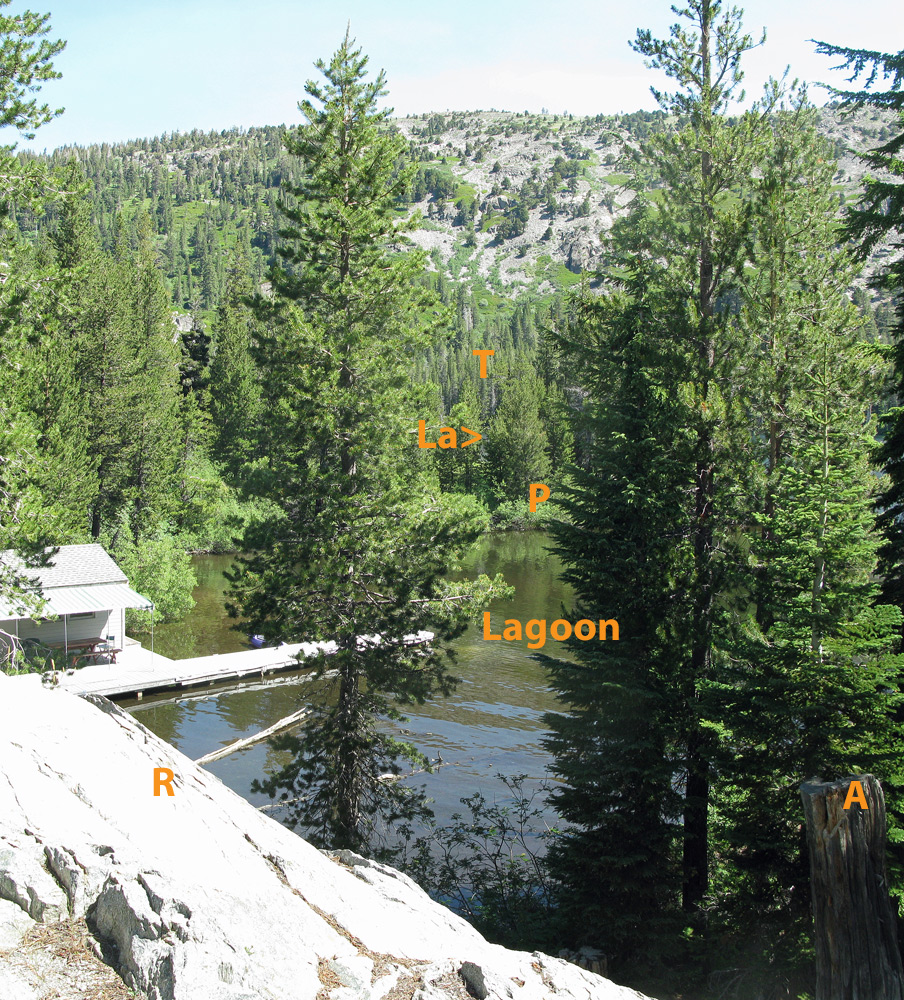 |
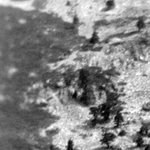
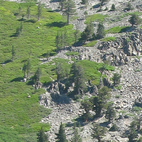
This pair of photos contains some of the most important news! Dorothy Moore was Dyke Brown’s mother and a professional photographer. She used a 4x5 large format view camera to take shots of Echo in 1928. The photos are incredibly clear and show great detail. Taken from the deck of her cabin overlooking a granite outcrop (R), this photo shows the lagoon, the point (P) the Upper Lake (La), the Public Boat Landing (PBL), and even a portion of the Desolation Wilderness Trail (dotted orange line above PBL). Today, so many trees have grown up on the near shore, the point and the far shore that it is impossible to see the public boat landing or the Desolation Trail; the lake is only a tiny speck here and there; and the point has changed dramatically. The large tree (A) is now a large stump. In Area T, the trees on the far shore are much thicker and taller today than in 1928.
But the most interesting part is still to come. Let's blow up Dorothy's photo and look more closely at the point.
1928, Close-Up of Point |
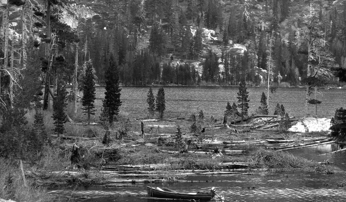 |
There are large dead trees laying all over the place, with a scattering of live small trees here and there, and a few large live trees still standing. The scenario that makes the most sense to explain this strange landscape is that there was a large fire about 30 years prior to Dorothy’s photo. It burned most of the small, mid and large size trees in this southwest corner of the upper lake (and possibly much further), leaving just a few larger trees intact. Most of the burned trees were standing dead for a decade or two, but then fell over (perhaps when the lake level rose from the dam building), while new seedlings gradually gained a toe-hold and started growing up between the dead giants.
But is there any evidence to support this theory? There is if you enlarge the photo even further.
1928, Really Really Close-Up of Point |
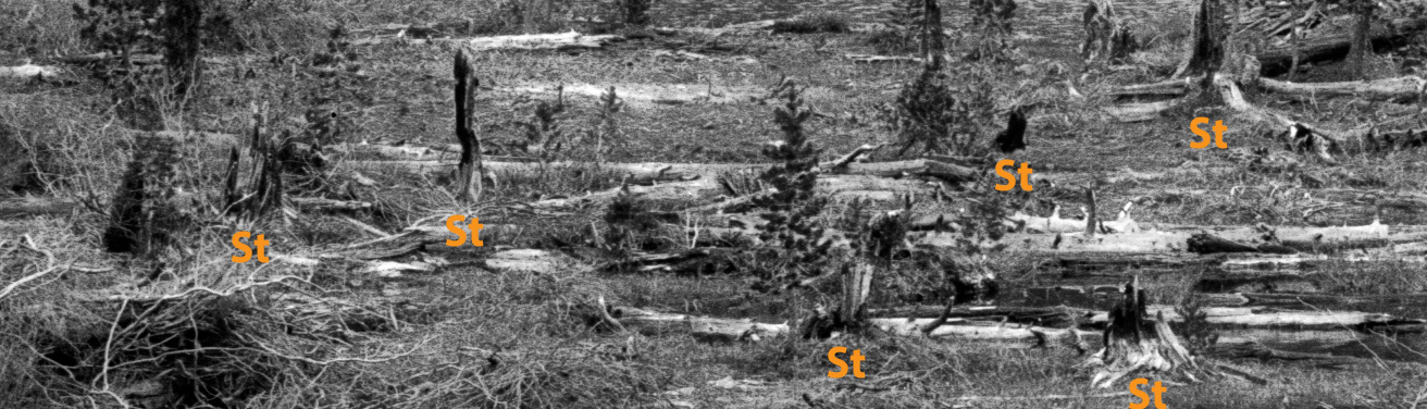 |
All of a sudden you can pick out the bizarre shapes of wild-fire-blackened stumps (above the St's) dotting the point. These shapes will look familiar to those of you who have hiked in wildfire areas.
So Echo has burned, probably 110-120 years ago, around 1890 to 1900. Why don’t we know about it? Well, the Forest Service was not formed until 1905. Fighting forest fires did not become the imperative of the Forest Service until the Great Fire of 1910, which burned 3 million acres, destroyed 5 towns and killed 87 firefighters. Before that folks did not have much ability to fight forest fires. Hardly anyone was up here in the forest then, and folks just let fires burn, not making much note of them.
Photo pair #2: Dyer Cove, Channel Tract 8 or so, Northeast quadrant of Upper Echo Lake, 1950 and 2013
| 1950 | 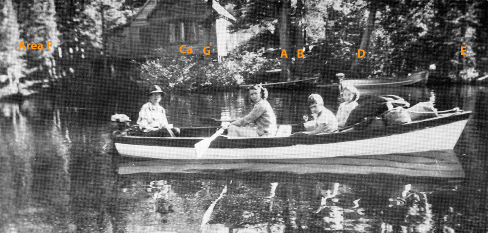 |
| 2013 | 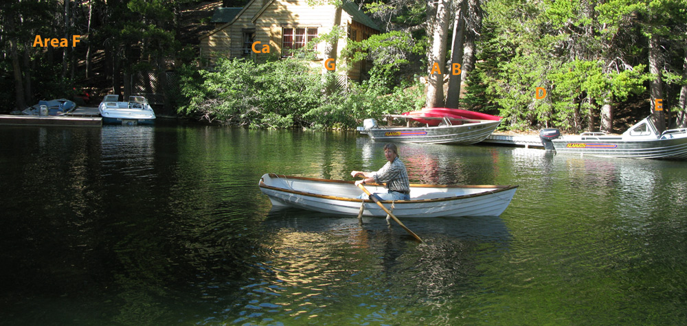 |
Some places like this quiet cove seem unchanged with time. Cabin (Ca) and trees (A, B, D, E, G) are still much the same, though bigger. Area F has grown up, the little trees becoming the deep dark forest.
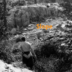
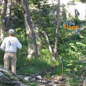
Photo pair #3: Behind Dyke Brown Cabin, Hemlock Tract #13, Upper Echo Lake, 1934 and 2013
| 1934 | 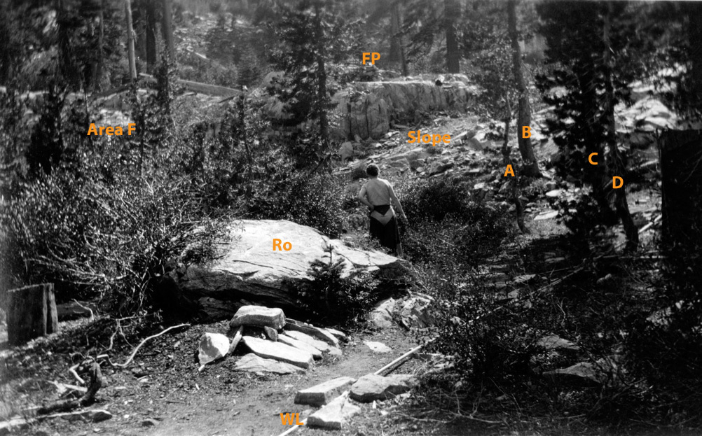 |
| 2013 | 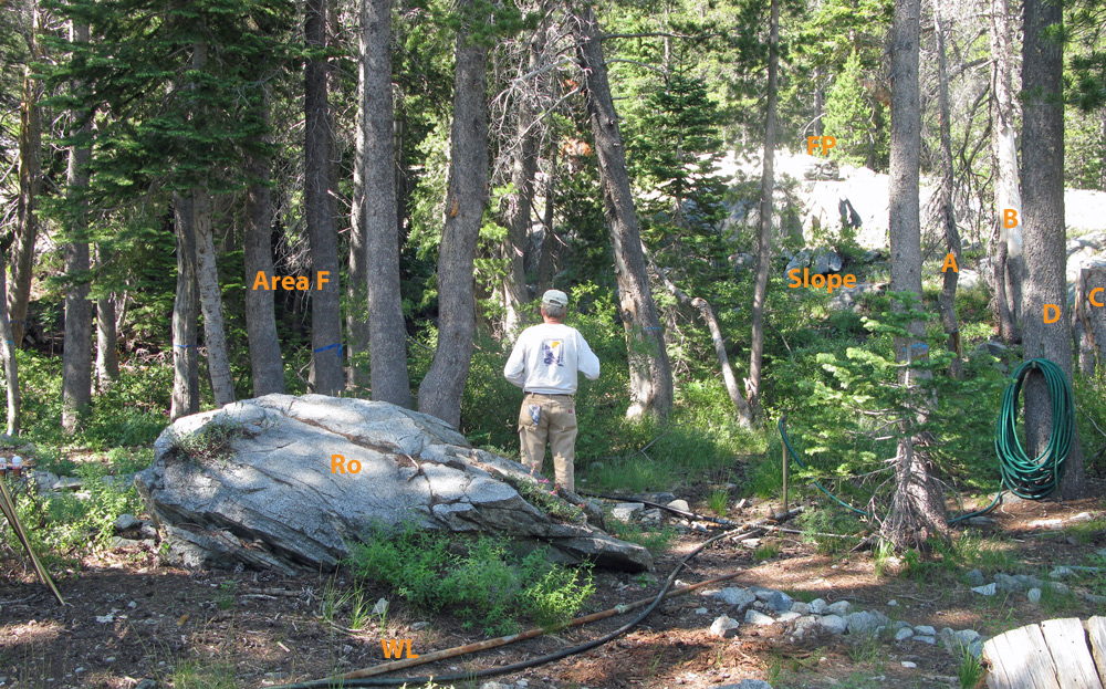 |
Here the forest has grown taller. Rock (Ro), Water line (WL), Fire pit (FP) and trees A, B, C, and D are all still there. (Because I was not in the exact right location, if you examine this pair closely you will see that some things do not appear at the right angles, nor do they line up exactly in the modern photo.) The trees in Area F have grown up considerably and are now the deep dark forest. Also note the increased duff between the rock and water line today. The forbs and small bushes on Slope are much bigger and thicker now than in 1934. They may have been severely burned back in an earlier fire, the soil may be better now from the increased duff from the trees, or global warming and nitrate loading from air pollution may also be at work.
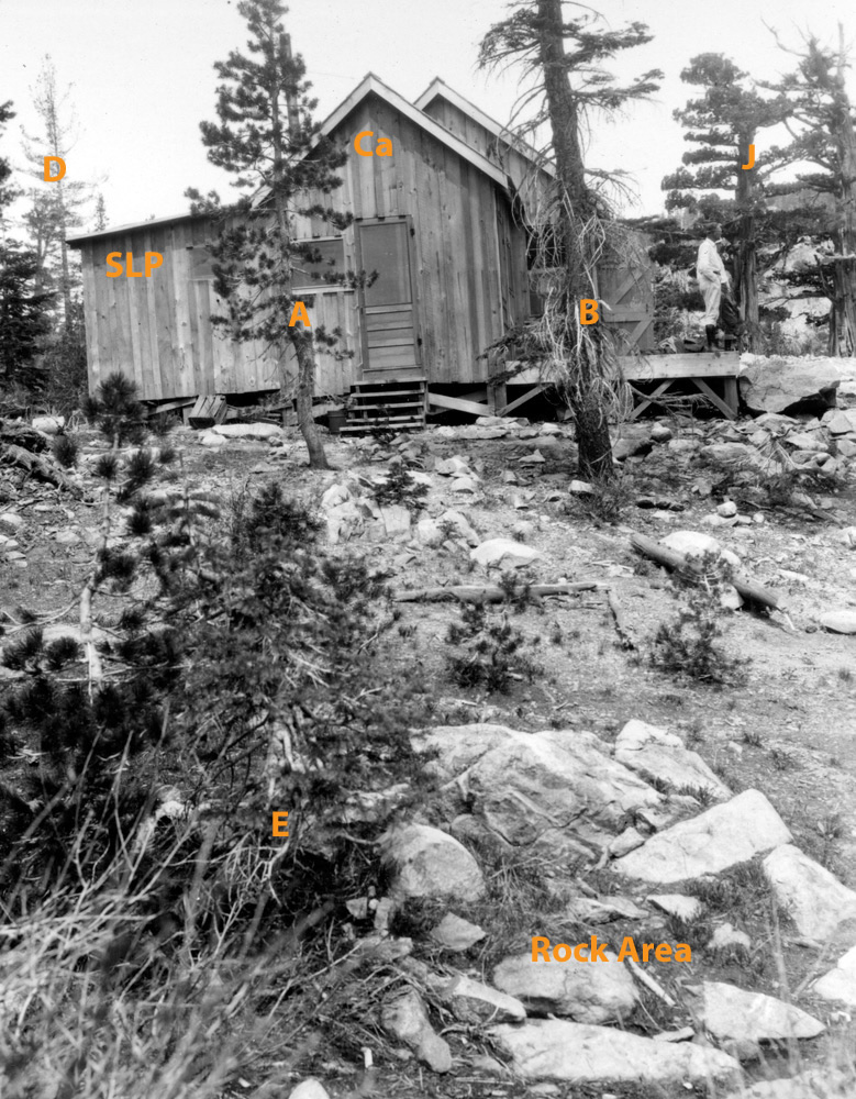
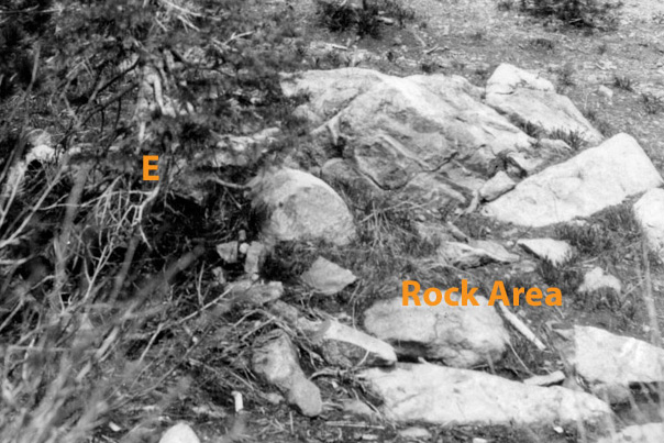
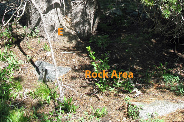
Photo pair #4: East side Dyke Brown Cabin, Hemlock Tract #13, Upper Echo Lake, 1934 and 2013
1934 |
2013 |
 |
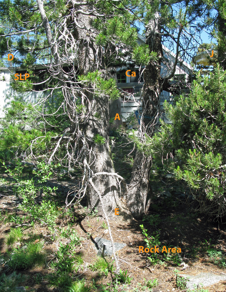 |
Cabin (Ca) and sleeping porch (SLP) are barely visible through Tree E which has grown up in the last 79 years. (The sleeping porch today does not match exactly since it has been extended.) Trees A, J, D and E are much bigger now. Tree B has been cut down in the intervening years. Again note the increased duff coverage in Rock Area. The soil in the 1934 photo looks highly mineralized with very little organic matter on it; the forbs and grasses appear stunted. The whole site looks quite eroded in 1934, perhaps due to cabin construction a decade before, but also perhaps due to a large fire having scoured the soil of organic matter several decades previously.
Photo pair #5: Dyke Brown Dock, Hemlock Tract #13, Looking across Upper Echo Lake, 1934 and 2013
1934 |
2013 |
 |
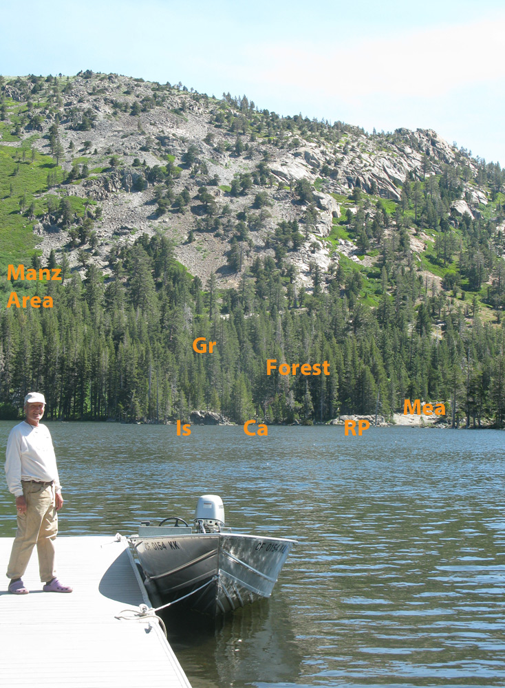 |
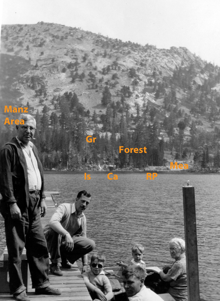
Across the lake you can see a rock point (RP), island (Is), and cabin (Ca), although the cabin is barely visible today because of more trees. The meadow (Mea) of 1934 is much smaller today, with many more trees in the lower forested areas (Forest). The forest is much thicker, taller, and extends much further up the slope today than in 1934. There are granite outcrops (Gr) in 1934 which are no longer visible today through the denser forest. Some of the manzanita areas (Manz Area) appear a little thicker and look like they have slightly extended their footprints today.
Photo pair #6: Dyke Brown dock from deck, Hemlock Tract #13, Looking across Upper Echo Lake, 1934 and 2013
1934 |
2013 |
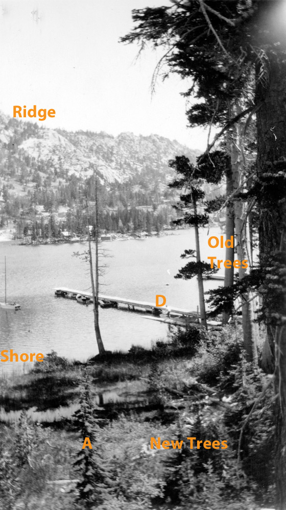 |
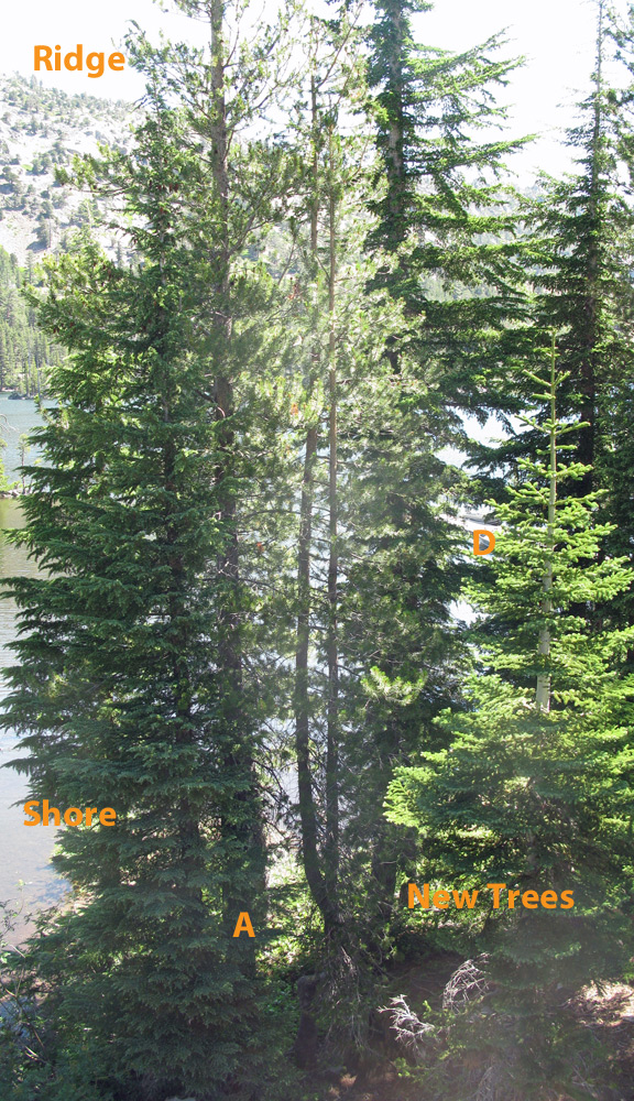 |
Today the far side of the lake (Ridge), the dock (D) and the shoreline (Shore) are barely visible through all the new trees which have grown up along the shore. Some of the Old Trees are still there but invisible through the new trees. The shoreline has eroded back significantly since 1934, perhaps due to motor boat wakes or the exploding geese populations, which have eradicated much of the grasses and marshes along the shores of Upper Echo Lake. The old trees in the 1934 photo look like they have had a hard life. Have they been through a fire? Is that why there are only old trees and very young trees in this view? Why are there no mid-sized trees here in front of the cabin in 1934?
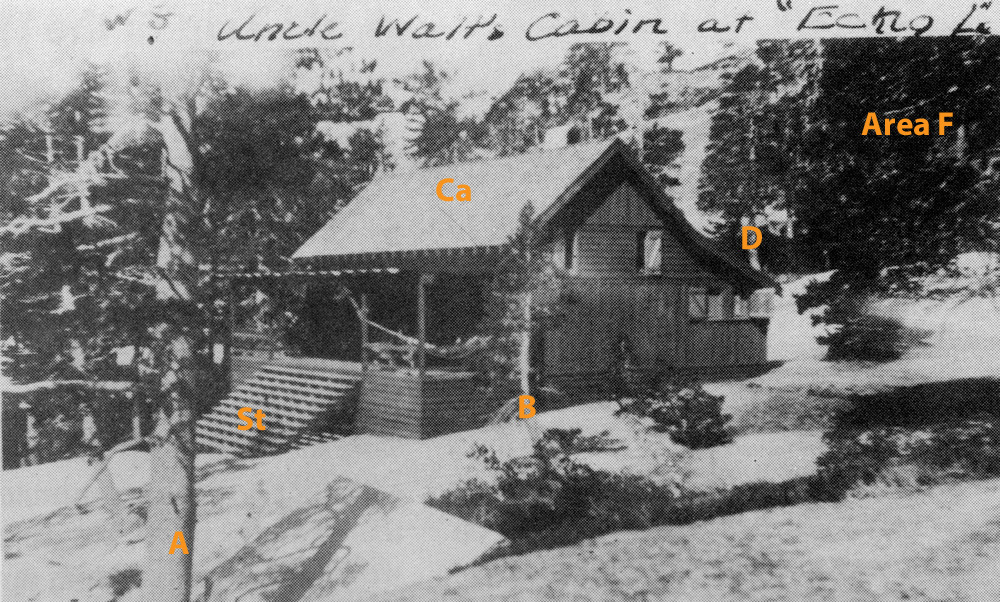
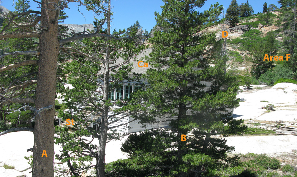
Photo pair #7: Formichelli-Gibson Cabin, Mermaid Cove #6, Lower Echo Lake, unknown date (1930's?) and 2013
 |
1934 |
 |
2013 |
Even on the Lower Lake on hotter south facing slopes it seems that the trees have been growing, though perhaps not as much. Cabin (Ca) and staircase (St) are now obscured by trees A and B. Tree D has died though it is still standing. And Area F seems to have LOST trees in the intervening years. Due to fire? beetle kill? firewood collecting?
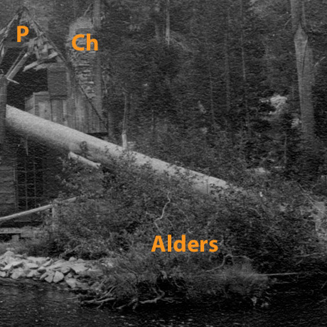
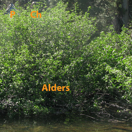
Photo pair #8: H. E. Brown Cabin, Hemlock Tract #11, Upper Echo Lake, 1930's/40's and 2013
1930's or 40's |
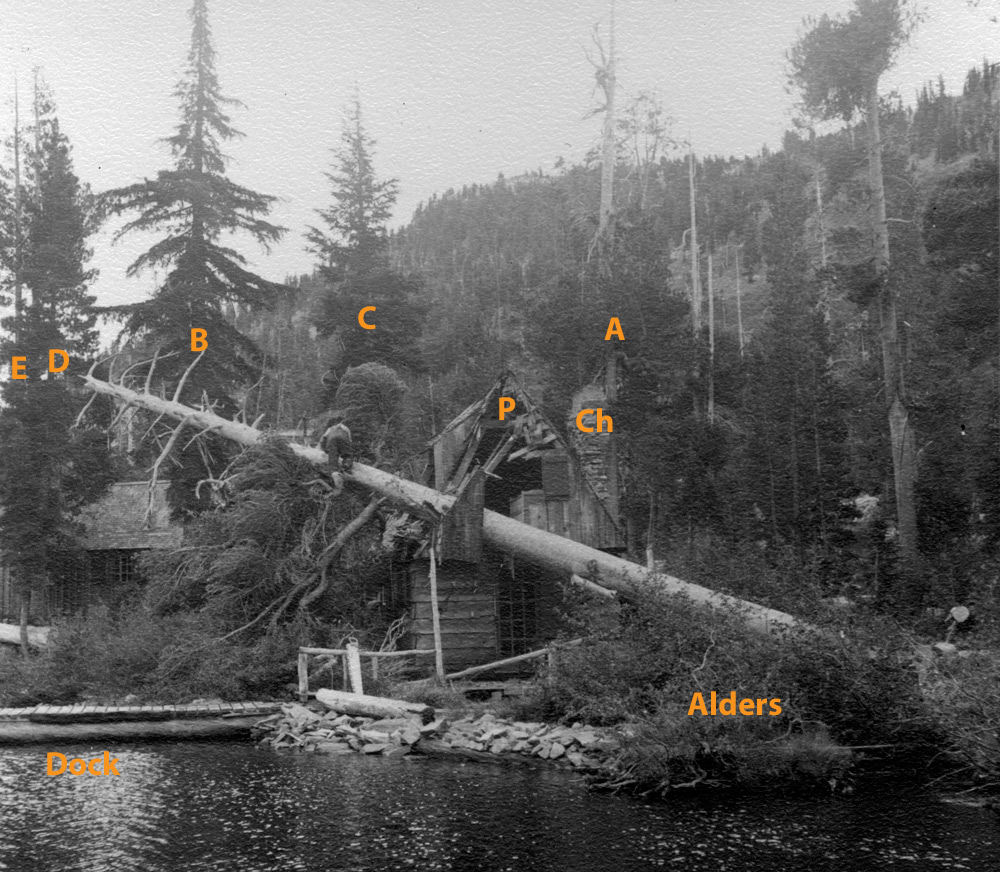 |
2013 |
 |
I was not standing in the right place when I took this picture so the trees and cabin do not line up correctly in the 2013 photo. Nevertheless, LOOK AT THOSE ALDERS! They obscure almost the entire cabin with only a bit of the peak of the cabin (P) and chimney (Ch) visible above them today. What accounts for their tremendous growth? Is there more nitrate loading at Echo from air pollution now? Is climate change giving them a more temperate climate and a longer growing season? Were they stunted in the 1930's because of a previous fire? Or were previous cabin owners always hacking away at them so the alders wouldn't obscure their view? Trees A, B, C, D, and E are still standing but have been joined by more mid-sized trees today which obscure the view of the distant ridge and hillside. (And most important, today the H. E. Brown cabin no longer has a tree on top of it!)
Photo pair #9: Lagoon and point , Looking across Upper Echo Lake, 1925 and 2013
1925 |
2013 |
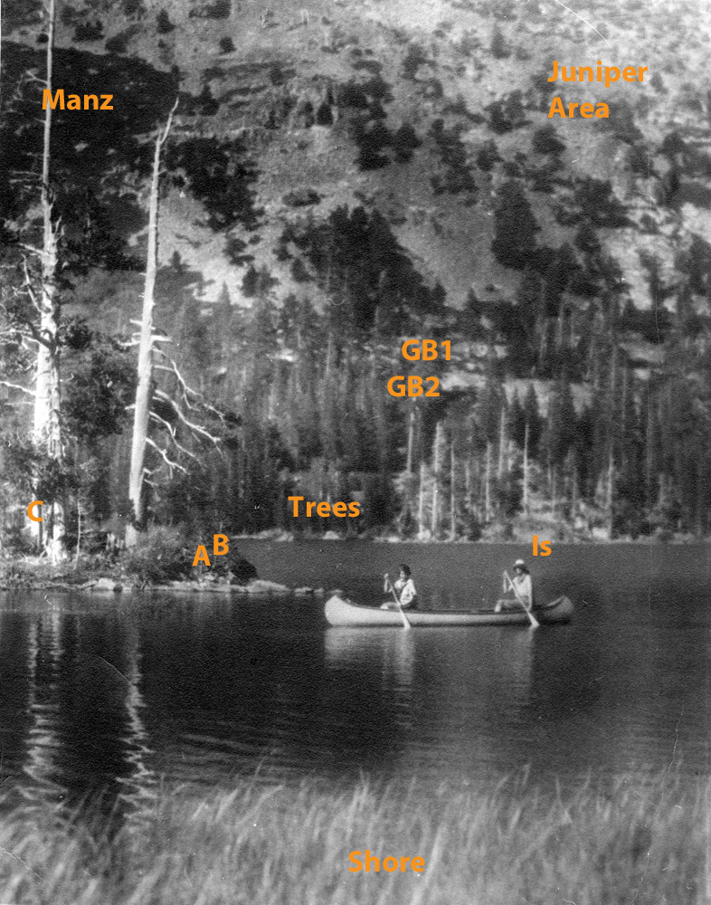 |
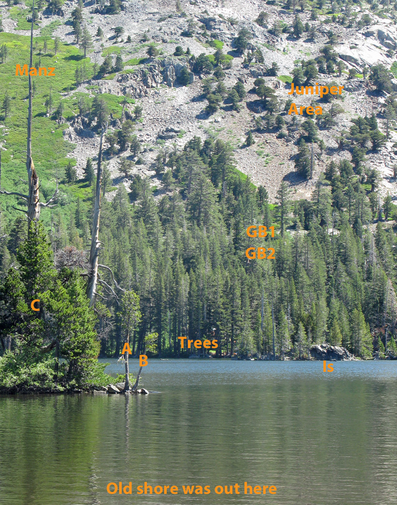 |
The water level of the lake is higher in the 2013 photo. Nevertheless, the shoreline has changed drastically in the intervening years, the grasses and sedges bordering the near shoreline of the lagoon of 1925 a distant memory. Trees A, B, and C have not grown very much, perhaps due to higher water levels drowning their roots and a general lack of soil on the end of the point. The Island (Is) and distant shore have many more trees, much taller trees, and the trees extend much further up the slope today than in 1925. Granite Bands #1 and #2 (GB1 and GB2) are plainly visible in 1925, but today only Granite band #1 is visible through the trees. The upper slopes of Echo Peak (Juniper Area) appear relatively unchanged, with junipers mainly getting a little larger. The talus dots you can see in the Manzanita Areas (Manz) in 1925 have pretty much disappeared today, suggesting that the manzanita is thicker and bigger.
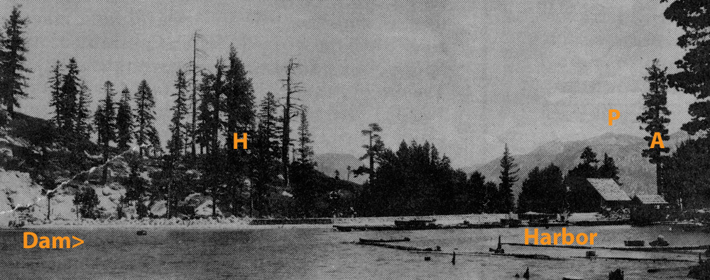
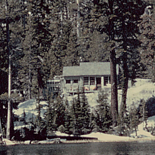
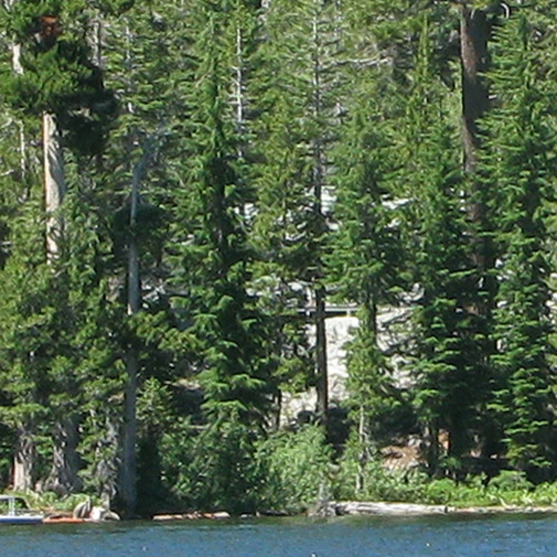
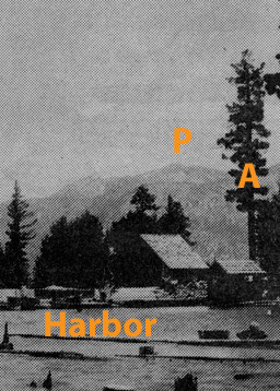
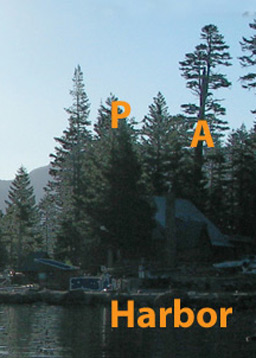
Photo pair #10: Lower Echo Lake Landing, Chalet, Dam and Harbor, 1928 and 2013
1928 |
 |
2013 |
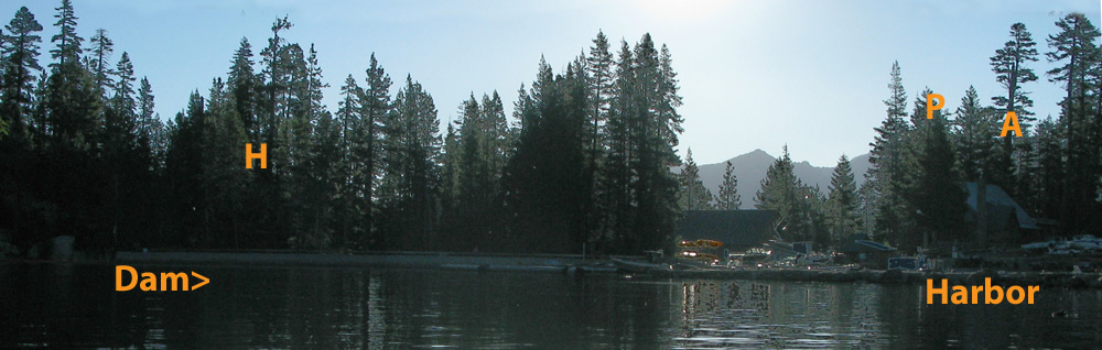 |
The Lower Lake has changed quite a bit too over the years, with several generations of dams (Dam>), harbors, chalets and boat barns. However, the hill (H) and distant peak (P) are still the same, though today they are obscured by many more trees. Tree A is the only one I could identify in both photos. If I could retake this view from shore rather than a bobbing boat, lined up correctly, and not at first light, it might be possible to identify more of the original trees and changes to the shoreline.
Photo pair #11: Lower Lake near Channel , Looking across Upper Echo Lake to Mermaid Cove, 1932 and 2013
1932 |
|
2013 |
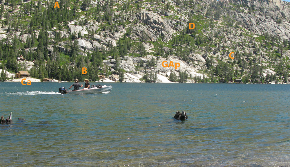 |
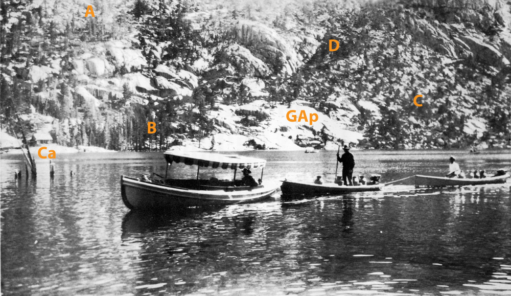
Across the lake the cabin (Ca) on its granite point and the granite apron (GAp) are distinctive landmarks. But again, trees and manzanita are spreading further than they were in 1932, though not as much as on the Upper Lake. Trees in Area B along the shoreline are much thicker and more numerous than in 1932. The grove of trees below the letter A has enlarged considerably in the last 81 years. In area D the trees are much the same but the manzanita appears thicker. Below the letter C the trees are more numerous and there is more manzanita. If anyone has a better quality scan of this historic photo, please email it to me and I will replace the one above.
Photo pair #12: North Shore Upper Echo Lake Near Dyer Cover, Looking West, Upper Echo Lake, 1925 and 2013
1925 |
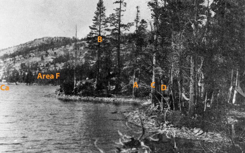 |
2013 |
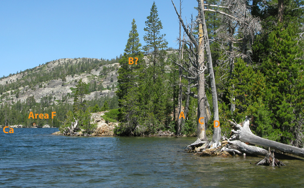 |
This view does not appear to be much changed. The lake is higher, which has changed the shape of the shoreline. Trees A, C, and D are still standing although dead. Tree B may still be standing although it is hard to tell if it is the same tree. Area F appears to have somewhat taller thicker trees. If anyone has a better quality scan of this historic photo, please email it to me and I will replace the one above. It might make identifying landmarks and trees much clearer.
Photo pair #13: Sproul, D Brown, Freeborn, & H E Brown Cabins , Hemlock Tract, from Upper Echo Lake, 1969 and 2013
1969 |
|
2013 |
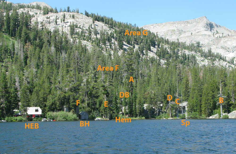 |
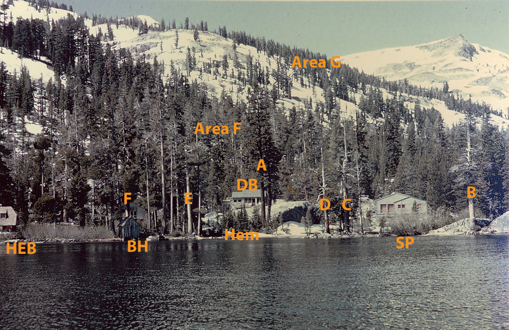
The Sproul (Sp), Dyke Brown (DB), Freeborn (F) and H. E. Brown cabins and the boathouse (BH) remain the same, but only the H. E. Brown cabin and the boathouse are clearly visible today at this camera angle from the lake. All the rest are partially obscured by taller trees on the point and hemlocks (Hem) along the shore. Trees A, B, C, D, E and F are still standing, along with many others. Trees D, C, and B are all on the point. Both Areas F and G appear to have more trees, and larger ones than they did in 1969.
Photo pair #14: Public Boat Landing, Desolation Valley Trail , Upper Echo Lake, 1930's and 2013
1930's |
2013 |
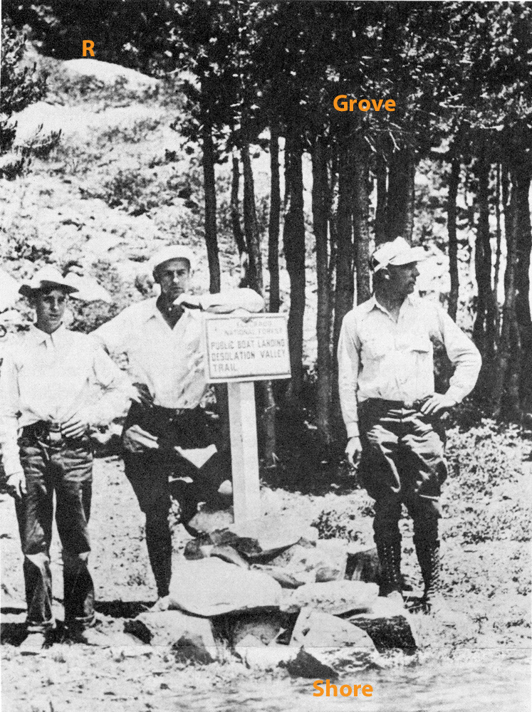 |
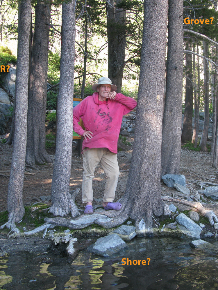 |
It was very difficult finding this exact location and we merely made our best guess. The shoreline where the young men are standing in the 1930's may be under water now. We could not find the same rock outcrop (R) as in the 1930's photo. Manzanita and brush have grown over many of the rocks, obscuring them. And any small grove of trees (Grove) has long ago grown up and thinned out. But the main thing missing in the 2013 photo is the sun. It is blocked out now by all the tall trees that currently cover the Public Boat Landing, casting it into perennial shade.
Conclusions - My Own
1. Echo has burned.
|
2. There are significantly more trees than there used to be on the Upper Lake in areas with soil. (Only 44 years of growth in photo below.)
 |
 |
3. The Lower Lake also has more trees than 80 years ago, but perhaps not as big an increase as the Upper Lake.
 |
 |
4. There is more duff on the ground now than there was 80 years ago.
 |
 |
5. Forbes and shrubs are more plentiful and larger than they used to be.
 |
 |
6. Alder thickets are taller and thicker than they used to be.
 |
 |
7. Manzanita thickets are spreading and covering more than they used to.
 |
 |
I hope you have enjoyed all this and learned something about our treasured landscape. I have kept the image sizes above large on purpose, so that you can copy and paste and blow them up further to examine them. If you would like a larger file for closer examination, please email me and I will send it to you.
I imagine that many of you have old photos of the lake too. You too can probably figure out where they were taken and go out and photograph what that old scene looks like today. An excellent source to help you re-photograph the landscape accurately is at this web site: http://www.thirdview.org/3v/classroom/index.html Perhaps you too have photographs that, when examined closely, might fill out this story of fire at Echo Lake. There’s a lot more to the story and if we keep the conversation going we might be able to figure out what has happened, and shed more light on the current state of our forest. Happy photographing!
![]()
Click here to see Elizabeth Black's paintings of Echo Lake.
![]()